| Camera Network |
Camera Name |
| PHENOCAM |
torgnon-ld |
|
Start |
End |
| Date |
N/A |
N/A |
| Time |
00:00:00 |
23:59:00 |
|
| Run analyses also for each polygon (ROI) separately: False |
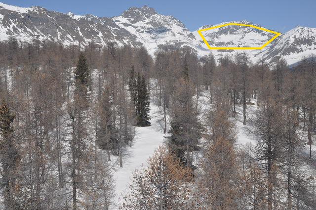
| Polygon | Image Coordinates | | 1 | 0.6283,0.1476,0.7323,0.1126,0.7919,0.1218,0.8848,0.1613,0.8253,0.2329,0.7626,0.2314 | 0.6657,0.2314
| ROI Geolocation information |
| Coordinate system: WGS84(EPSG:4326) | | Polygons do not directly correspond to image ROI polygons. |
| Polygon | Geolocation Coordinates | | 1 | 45.8743078656,7.56245458288 | 45.8707494594,7.5641430214,45.8707716984,7.56676950996,45.8700831848,7.57118108634,45.8753040166,7.57661696445,45.876280682,7.57592952165,45.8773555078,7.57418198211,45.8789773652,7.56992743751,45.8790887445,7.5661783392,45.8779049529,7.56184677015,45.8743078656,7.56245458288
| Type |
Value |
Minimum |
Maximum |
| Image Threshold |
Brightness |
0.35 |
1.0 |
| Image Threshold |
Luminance |
0.0 |
1.0 |
| Image Threshold |
Red Fraction |
0.0 |
1.0 |
| Image Threshold |
Green Fraction |
0.0 |
1.0 |
| Image Threshold |
Blue Fraction |
0.0 |
1.0 |
| ROI Threshold |
Red Fraction |
0.0 |
1.0 |
| ROI Threshold |
Green Fraction |
0.0 |
1.0 |
| ROI Threshold |
Blue Fraction |
0.0 |
1.0 |
| Pixel Threshold |
Red Channel |
0.0 |
254.0 |
| Pixel Threshold |
Green Channel |
0.0 |
254.0 |
| Pixel Threshold |
Blue Channel |
0.0 |
254.0 |
| Pixel Threshold |
Grey Composite |
0.0 |
255.0 |
|
| Analysis No |
Analysis Name |
Analysis Parameters |
| 1 |
Snow Cover Fraction - SNOWCOV001 |
| Parameter |
Value |
| Include Red Channel |
Not Selected |
| Include Green Channel |
Not Selected |
| Include Blue Channel |
Selected |
| Store mid-step and extra output data |
Not Selected |
| Use georectification |
Not Selected |
| Spatial extent |
0;0;0;0 |
| Spatial Extent Coordinate System |
WGS84(EPSG:4326) |
| Spatial resolution |
1 |
| DEM Dataset |
NLS-DEM2 |
| Camera coordinates |
0;0 |
| Camera coordinate system |
WGS84(EPSG:4326) |
| Camera Height |
10 |
| Horizontal position |
0.0 |
| Target Direction |
0.0 |
| Vertical position |
0.0 |
| Focal length |
24 |
| Scaling factor |
1 |
| Interpolate DEM Data |
Selected |
| Flat terrain |
Not Selected |
| Radial Center |
0.0;0.0 |
| Horizontal coefficient |
0.0 |
| Vertical Coefficient |
0.0 |
|
No results data to show.
|